he Devils Dyke is one of the best preserved Anglo-Saxon earthworks in England. Thought to have been built by the Saxons in the 6th and 7th centuries AD to keep those Britons at bay, the bank and ditch stretches for 12 kilometres between the villages of Reach and Wood Ditton. The chalk grassland environment is home to several unusual flowers – the Pasque Flower in April/May, the Lizard Orchid in late June/early July and Bellflowers throughout July and August. This walk includes options of a 1 or 2 kilometre stretch along the top of the dyke, or beside the ditch for less adventurous souls. This route has become very popular of late and many feet lead to muddy conditions over the winter months. Drier weather makes the circuit more enjoyable.
The described circular route, shown on Ordnance Survey Explorer Map 210 Newmarket and Haverhill, takes less than two hours to complete but there is the opportunity of adding another hour by continuing along the top of the Dyke until you reach the Cheveley to Dullingham road. These directions concentrate on the lesser circuit. If you wish to include a picnic during your outing there are several fallen trees on which to perch.
Park at the Ellesmere Centre in Stetchworth High Street where there are toilets open from 8.30am to 10.00pm and a small shop which is open mornings only Monday to Friday (closes at 1.00pm).
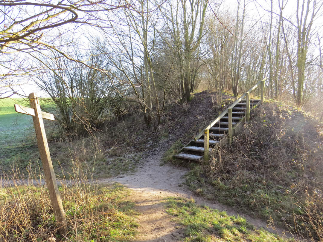
Leave the car park entrance and turn right. You will soon pass Coopers Close and an attractive row of terraced flint cottages on the right. Take the footpath on the right, just before the pub., signed to Devils Ditch and Woodditton. Cross a road and continue on the footpath on the other side. You will reach a large field and you should continue down the left-hand side soon leaving behind the bungalows and a hedge. Continue down the side of the field, now with mature trees on your left and you will see the Dyke stretching to the right and left in front. Cross the Dyke, there is a dip in the profile, veer slightly right and follow a between-fields path ahead. On a clear day Ely Cathedral can be spotted on the horizon to the left. Climb some steps and turn right along a hard surface track. This is a section of the Icknield Way long distance path which soon swings to the left. There is a mass of waymarks at the point and you must continue ahead now with a small wood on your left. Go through a metal gate. Veer left at the next junction away from what appears to be the main path. There is a waymark on a fence post ahead. Follow this grassy path past stables and horse paddocks to join the main drive. Continue through a side gate and climb up to pass a water tower on the left. If you need a break on reaching the road continue ahead for 100 paces to find a seat beside a memorial crown. If not, turn right and after eighty paces turn right again, between gardens (as directed by a fingerpost reading Reach 7½ miles) At the end of the gardens veer left to cross a small field. At the far side you will find the beginning of the Dyke and have to make a big decision. You can go through the gap in the hedge on your left and take a flat, short and reasonably safe meander through trees (and bluebells in April/May) before reaching the open fields again. You then turn right and follow the headland back to the place that you crossed the dyke some 45 minutes ago. OR you can be more adventurous and take the top of the bank option behind the information board. This is best avoided in wet weather but is great fun if dry underfoot. The path does undulate somewhat and there are steps and small wooden bridges at intervals but the main hazards are roots and branches. Remain alert and no harm will befall you. Either of these alternatives will bring you back to the dip in the Dyke (steps with a handrail leading down and a wonky 4-way signpost) and the crossing. Turn left unless you wish to extend the walk.

If you do, continue along the bank top. This section is more open so you face fewer challenges. Reach the road and turn left. This is a minor road but it does host the occasional speeding white van but the grass verge on the right is level and offers sanctuary. At the offset crossroads by the Lodge turn left and follow the pavement back into the high street and eventually to the Ellesmere Centre.
For the shorter version continue up the right side of the large field. There is a well-used ‘villagers path’ in the tree belt to the right but be aware that this is not an official right of way. At the end of the large field/s on the left and soon after reaching the bungalows on the right turn left at a footpath junction now walking behind gardens. The path will bring you into the playing fields. Stay with the right-hand side and this will lead you back to the car park.
Roger Medley
Re-walked January 2023
This series of walks have been put together by Roger Medley.
If any of the walking notes are confusing or inaccurate or the information is wrong, please contact Roger on 01440 820551. If they are helpful, or if you have any other comments, likewise.
Coming Soon to a Fingerpost near you
Suffolk County Council has received funding for a county wide initiative to encourage more people to explore the local area. A field officer has been appointed and volunteers have been recruited to attach plaques to fingerposts in individual parishes. Each plaque (see diagram) displays an app. which can be downloaded to modern Apple and android phones. This will display the local section of the Ordnance Survey map showing footpaths and recognised walking, cycling and riding trails. The information can be stored if walkers are visiting an area where there is limited phone cover. Plaques have been added to 44 stable fingerposts in Wickhambrook and where fingerposts are missing or unstable these have been reported. There are 18 of these and they will be replaced complete with plaques. Wickhambrook is one of the first parishes in the County to complete this task.
W.I.Walking Group
The Wickhambrook W.I. Walking Group meets every Wednesday morning at 10am starting from the MSC car park for walks in the village or slightly further afield. We walk for about two hours and cover about five miles, depending on how much chatting is taking place. There are usually six of us, although we have had a dozen occasionally, dogs are welcome too.